GPS tracking
The monitoring system tracks and controls mobile assets.
Main applications:
- passenger transport and minibus taxis,
- freight forwarders and haulage,
- tow trucks,
- emergency services,
- cash-in-transit services,
- construction and municipal vehicles.
The system has two parts: a tracking unit is installed in the vehicle, and a computer — in an office, for example — shows the vehicle’s position on a map and records its movement and status parameters.
The tracking system can:
- Track the current position of vehicles on a map in real time;
- Record every movement of a vehicle, its driving parameters and on-board sensor readings;
- Calculate the distance travelled by a vehicle;
- Detect speeding, leaving a defined area or deviating from the schedule in real time;
- View, analyse and print recorded route information;
- Give drivers the optimal route to a given destination;
- Replay recorded routes for a selected period at accelerated speed.
The data collected makes it possible to:
- Protect vehicles and check cargo integrity;
- Control various actuators installed on the vehicle;
- Cut operating costs (in particular fuel, lubricants and engine life) by optimising routes.
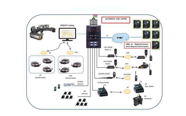
Various communication technologies are used to send position data from the vehicle to the dispatch centre:
Satellite communications. Data is sent via satellite terminals and covers most of the globe. Satellite-based systems offer almost 100% coverage but are expensive to operate.
HF radio. Provides wide-area coverage but requires the most expensive equipment. Running costs, however, are very low.
VHF radio. VHF-based tracking requires dedicated communication infrastructure. The equipment is small and inexpensive.
TCP/IP UDP links. The most cost-effective option in terms of equipment, but dependent on the GPRS coverage of national mobile operators. Before choosing this option, check coverage in your area of operation with your mobile operator.